Tuesday, 26 January 2021

Beyond Monuments: Ancient Maya Landscapes Revealed Through Technology


Walking through this lush, tropical forest, visitors may not realize at first that they are among the monumental remains of a large ancient Maya center. Where are all the great stone pyramids, ball-courts, temples, and other monuments so often attributed to great ancient Maya centers? Yet, one sees a tropical landscape that is anything but flat. There is a jungle-shrouded mound here, another one over there. A well-planned walking path winds through what a visitor might describe as the Maya version of the Garden of Eden. Like the very first 18th and 19th century explorers of the Maya world, one sees what could be ancient structures still hidden beneath their canopy shroud. Some of them here have now been partially exposed, betraying what might lie beneath and leaving the rest to the imagination. Visitors soon acquire the impression that this place is very different than any other encountered in the Maya world. Straddling the border between Guatemala and Belize, it is known as El Pilar. It has been explored and studied by archaeologist Dr. Anabel Ford of the University of California, Santa Barbara for decades.

Read the rest of this article...

Sunday, 24 January 2021

A New Archaeology For The Anthropocene Era

Archaeological studies of low-density, agrarian-based cities such as ancient Angkor Wat
in Cambodia are increasingly being used to inform the development of more
sustainable urban centres in the future [Credit: Alison Crowther]

A paper published in Nature Ecology and Evolution aims to give pause to an audience that has been largely prepared to take such out-of-touch depictions at face value. It reveals an archaeology practiced by scientists in white lab coats, using multi-million-euro instrumentation and state-of-the-art computers.

It also reveals an archaeology poised to contribute in major ways to addressing such thoroughly modern challenges as biodiversity conservation, food security and climate change.

"Archaeology today is a dramatically different discipline to what it was a century ago," observes Nicole Boivin, lead author of the study and Director of the Institute's Department of Archaeology. "While the tomb raiding we see portrayed in movies is over the top, the archaeology of the past was probably closer to this than to present-day archaeology. Much archaeology today is in contrast highly scientific in orientation, and aimed at addressing modern-day issues."

Read the rest of this article...

Tuesday, 5 January 2021

NEW VISUALISATIONS, SAME DATA


Data are at the core of what we do as archaeologists, so facilitating the effective interrogation, interpretation and understanding of those data is vital. As part of a new digital strategy, Oxford Archaeology has overhauled core internal workflow systems by developing a series of digital modules designed to enhance the value of is large range of field data.

OA WebMap

The OA WebMap module was envisaged as a means of providing a modern yet familiar interface to the spatial and contextual data collected within our fieldwork projects. A web-based approach was chosen to reduce the need for specialist software.

In the field our survey methodology was adapted to a more attribute-driven approach, allowing more consistency in data capture and quality control. The underlying data schemas are more tightly defined as the data moves from GPS to GIS to WebMap. This means that survey data sent back from the field can be uploaded into the WebMap database as soon as it is processed and checked, often before the surveyor is back in the office.

There are many benefits once a site is uploaded into the OA WebMap system. Current site survey and related information can be easily viewed on any internet-enabled device by any member of staff. Site information is presented as categories of styled layers which can be turned on and off as desired to allow the user to visualise just the data they need.

Read more at In Touch Issue 54 pp 14-15

Following the Roman Army between the Southern Foothills of the Cantabrian Mountains and the Northern Plains of Castile and León (North of Spain): Archaeological Applications of Remote Sensing and Geospatial Tools


Sixty-six new archaeological sites have been discovered thanks to the combined use of different remote sensing techniques and open access geospatial datasets (mainly aerial photography, satellite imagery, and airborne LiDAR). These sites enhance the footprint of the Roman military presence in the northern fringe of the River Duero basin (León, Palencia, Burgos and Cantabria provinces, Spain). This paper provides a detailed morphological description of 66 Roman military camps in northwestern Iberia that date to the late Republic or early Imperial eras. We discuss the different spatial datasets and GIS tools used for different geographic contexts of varied terrain and vegetation. Finally, it stresses out the relevance of these novel data to delve into the rationale behind the Roman army movements between the northern Duero valley and the southern foothills of the Cantabrian Mountains. We conclude that methodological approaches stimulated by open-access geospatial datasets and enriched by geoscientific techniques are fundamental to understand the expansion of the Roman state in northwestern Iberia during the 1st c. BC properly. This renewed context set up a challenging scenario to overcome traditional archaeological perspectives still influenced by the cultural-historical paradigm and the pre-eminence of classical written sources.

Monday, 4 January 2021

Discovering a lost Viking waterway


The discovery of a series of lost waterways across West Mainland Orkney offers new insight into trade and transport across the area in the medieval period.
[Image: University of St Andrews]

New research involving a combination of geophysical mapping, sediment sampling, and the study of place-names has identified a network of waterways that ran through West Mainland Orkney in the Viking and late Norse period.

Examples of Old Norse place-names can be found all over northern Scotland and the Isles, originating in the medieval period, AD 790-1350, and reflecting when Scandinavian earls held power in Orkney. The recent research was prompted by the observation that there are several places that have names with sea- or boat-related connotations but are located far inland in central Orkney today. These include Greenay (meaning shallow waters) and Knarston (derived from the Old Norse words for a transport vessel and a farm where such vessels were moored). Scientific investigations have now been able to shed light on this mystery, revealing that these sites were in fact located along a previously unknown series of ancient waterways.

Read the rest of this article...

Ancient Viking waterway discovered in Orkney


A lost Viking canal system that acted as a trade and transport highway, has been discovered running through Orkney.

The route connects the North Atlantic with the Scapa Flow and crosses the Scottish archipelago’s mainland.

A series of Old Norse place names around the island, connected to the sea and boats, first sparked the interest of researchers who then began investigations.

Modern scientific methods, geophysical mapping and sediment samples have now revealed that the area was connected through a series of ancient canals

Dr Alexandra Sanmark, of the University of the Highlands and Islands, said: “I am delighted with the outcome as multiple pieces of written and landscape evidence suggested the existence of the waterway.

Read the rest of this article...

Study Rewrites History of Ancient Land Bridge Between Britain and Europe


As recently as 20,000 years ago—not long in geological terms—Britain was not, in fact, an island. Instead, the terrain that became the British Isles was linked to mainland Europe by Doggerland, a tract of now-submerged territory where early Mesolithic hunter-gatherers lived, settled and traveled.

Doggerland gradually shrank as rising sea levels flooded the area. Then, around 6150 B.C., disaster struck: The Storegga Slide, a submarine landslide off the coast of Norway, triggered a tsunami in the North Sea, flooding the British coastline and likely killing thousands of humans based in coastal settlements, reports Esther Addley for the Guardian.

Historians have long assumed that this tsunami was the deciding factor that finally separated Britain from mainland Europe. But new archaeological research published in the December issue of Antiquity argues that Doggerland may have actually survived as an archipelago of islands for several more centuries.

Co-author Vincent Gaffney, an archaeologist at the University of Bradford, has spent the past 15 years surveying Doggerland’s underwater remains as part of the Europe’s Lost Frontiers project. Using seismic mapping, computer simulations and other techniques, Gaffney and his colleagues have successfully mapped the territory’s marshes, rivers and other geographical features.

Read the rest of this article...

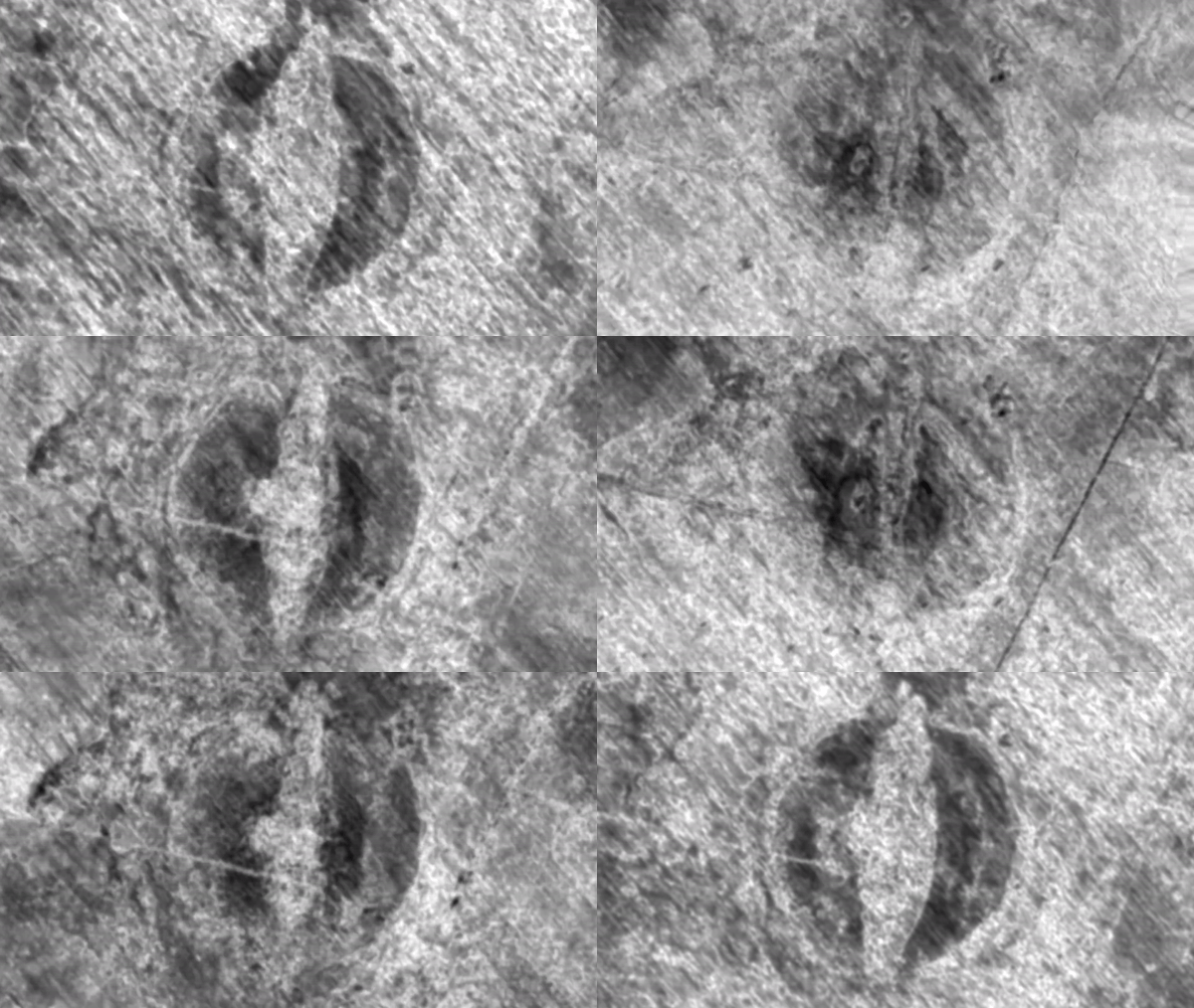
Fungus is destroying a buried Viking ship. Here's how Norway plans to save it.


Archaeologists are racing against the clock to save the remains of a buried Viking ship from a ruthless foe: fungus. 

If the project is successful, the 65-foot-long (20 meters) oak vessel — called the Gjellestad ship — will become the first Viking ship to be excavated in Norway in 115 years, said Sveinung Rotevatn, the Norwegian Minister of Climate and Environment. 

"Norway has a very special responsibility safeguarding our Viking Age heritage," Rotevatn told Live Science in an email. "Now, we are choosing to excavate in order to protect what remains of the find, and secure important knowledge about the Viking Age for future generations."

The ship is buried at a well-known Viking archaeological site at Gjellestad, near Halden, a town in southeastern Norway. But scientists discovered the vessel only recently, in the fall of 2018, by using radar scans that can detect structures underground. The scans revealed not only the ship, but also the Viking cemetery where it was ritually buried.

Read the rest of this article...


Coronavirus: Lockdown boost for archaeology as amateurs uncover Roman remains


 Lockdown has given archaeology an unexpected boost with volunteers finding previously unrecorded Roman, prehistoric and medieval sites from the comfort of their own homes.

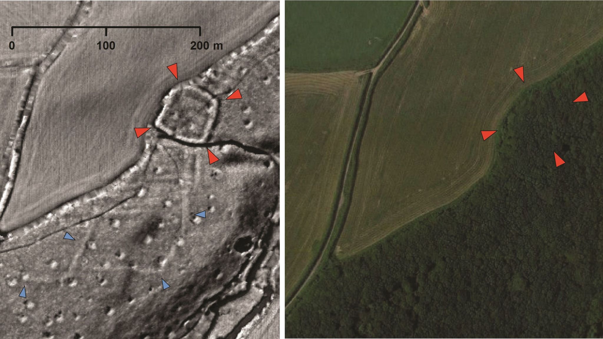
In a project coordinated by a team at Exeter University, enthusiastic amateurs have been analysing images derived from Lidar (light detection and ranging) data - laser technology used during aerial surveys to produce highly detailed topographical maps.

Modern vegetation and buildings can be digitally removed, allowing archaeologists to look at the shape of the land surface to find the remains of archaeological earthworks.

The data is being systematically examined and cross-referenced with records of known archaeology and historic maps, meaning the total of new discoveries regularly changes.

Read the rest of this article...

3D scanning gives new insight into 275-year-old Jacobite battlefield

Lidar technology has allowed experts to create a map of the Culloden battlefield, where the last pitched battle on British soil occurred in ...